| |
|
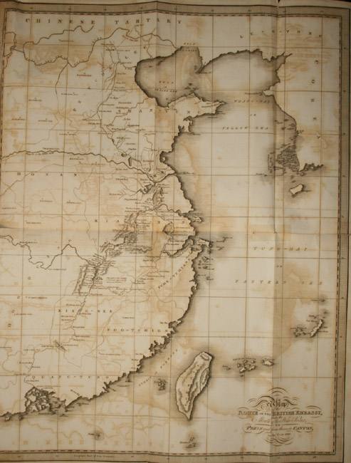 Map (frontispiece) from Henry Ellis: Journal of the Proceedings of the Late Embassy to China |
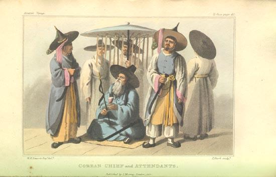
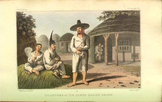
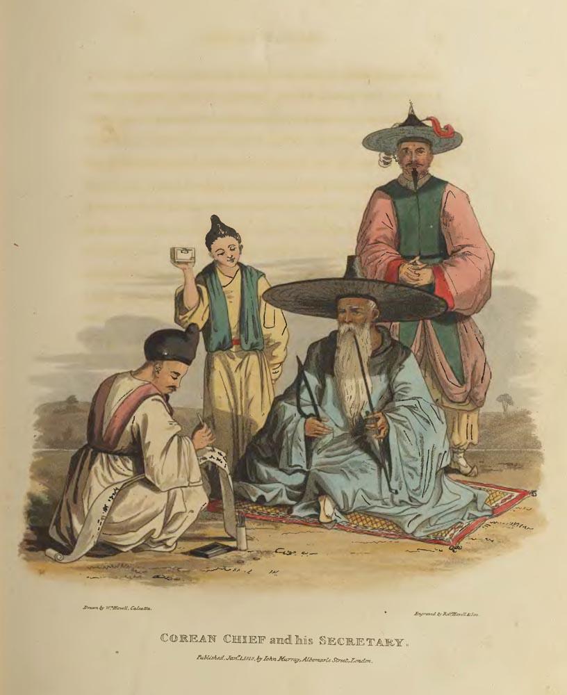
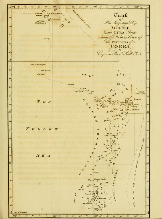 [Basil Hall, 1818, Appendix page x - xviii] NOTICE TO ACCOMPANY THE CHART OF THE WEST COAST OF COREA. This chart extends from 34º to 38º north latitude, and from 124º to 127º east longitude. The time of our stay on the coast being only nine days, no great accuracy is to be expected, and this chart pretends to be little more than an eye-draught, checked by chronometers and meridian altitudes of the sun and stars. Under circumstances of such haste, much has unavoidably been left untouched, and what is now given is presented with no great confidence. What follows is extracted from notes made at the time by Mr. Clifford and myself. The longitudes by chronometer have all been carefully recomputed, and the greatest care was taken in ascertaining the various latitudes. The true bearings are in every instance set down, the variation being allowed for at the moment. The variation of the compass recorded in this notice, was determined by two azimuth compasses, and the method recommended by Captain Flinders, of repeating the observations by turning the compass first one way and then the other, was invariably followed. His Majesty's ships Alceste and Lyra, after quitting the port of Oei-hai-oei, which is in latitude 37º 30' 40" north, and longitude 122º 16' east, on the north coast of Shantung Promontory, stood to the northward and eastward till in latitude 38º north, and then ran to the eastward. On the morning of the 1st of September, 1816, we saw the land, bearing about east. By sights with chronometer on the meridian of these islands, we ascertained that the west end of the northern one lies in 124º 44-1/2' east. The latitude of the south end of the eastern island was ascertained by meridian altitude of the sun to be 37º 44-1/2' north. There is a rocky white islet off the west end of the middle island. We had from twenty to thirty fathoms on rounding the south-west end of the islands, but on the south side of the southern one there is a bight with seven fathoms, black sand in the centre: here we anchored. There is good anchorage all over the bay, which is sheltered from all winds except between west south-west and south-east, being open to the southward. There are two villages here. From the top of the highest peak on this island, which is about seven or eight hundred feet high, we could discern the main land of Corea, high and rugged, stretching north north-west and south south-east, distant from eight to ten leagues. Along the coast abreast of us there were seen many islands. The channel between the middle island of the group and the one we were upon appeared clear and broad; but the northern and middle islands seemed connected by a reef which shews above water at several places. The inhabitants were suspicious and unfriendly: we saw some cattle and many fowls, but neither money nor any thing else that we had could induce them to part with either. In the evening we weighed and stood to the southward; next morning there was no land in sight. At noon we were in longitude 124º 47' 52" east, and latitude 36º 44-1/2' north, no land in sight. We hauled in shore to the eastward, and anchored in the night in deep water. 3rd of September.--Weighed at 3.30 and stood in shore; at 7.45 A.M. we were due south of the western of a group of islands. Many sights were taken as we passed to settle the place of this group: it lies between 125º 42-1/2' east, and 125º 57-1/2' east, and in latitude 36º 44' north. After passing this group we stood to the south-east towards a vast cluster of islands: at noon, when we were just entering the cluster, the latitude was observed 36º 18' 21" north, and longitude 126º 10' east. The south-west extreme of the islands bore south 40º west. There were eight islands near us between south-east and south-west, and a high bluff dark rock south one-quarter east, four miles: and on the main land a very high hill, east 19º north. When we had got well among the islands it fell calm, and we anchored in eight and a half fathoms. It remained calm during the night. 4th of September.--Weighed on a breeze springing up, and stood in shore. Observed in 36º 13' north, longitude 126º 30' east; at this time the following bearings were taken. A remarkable peak on the main land, east. High mountain on the main land, east 38-1/2º north. White cliff on the east end of the fourth island to the left of the wide entrance into the cluster, north. Small round island, north 30º west. Another, north 35º west. Extremes of a large bluff island from north 38º west, to north 32-1/2º west. Rock, north 72º west. Outer island, north 75º west. Extremes of the outer cluster, from north 77-1/2 west, to west 1º south. Large island, from west 14º 30' south, to west 18º south. These islands being within from ten to fifteen miles, were laid down by estimated distances, but it was quite impossible to assign places to the immense number of others which stretched away to the south and south-east, as far as the eye could reach. We stood in shore for the purpose of discovering whether there was any place of shelter in the main land, but in general it proved shallow and unsafe. At length we discovered a bay which promised shelter, but on running into it, the depth was found not to exceed three or four fathoms. This bay is open towards the south, and is formed by a curved tongue of land on the north and west. The longitude of the south end of this point is 126º 42' 22" east, and latitude 36º 7' 38" north. We remained here during the night, and the forenoon of the 5th. The natives came on board, but made great objections to our landing. The tide rose and fell fifteen feet and a half; it was low water at 8 P.M., and high water at 2.30 A.M. This was two and a half days before full moon. The Alceste's boats were sent to sound in the eastern quarter, but they found shoal water every where. 5th of September.--At 11 A.M. we got under weigh and stood to the south-west among the islands, carrying seven, eight, nine, ten, to fifteen fathoms, and occasionally deepening to seventeen fathoms. At 4.45 we observed in longitude 126º 24-1/2' east, and latitude 35º 52' north at this time. Two islands bore north half east, seven miles. A remarkable small black island, west 32º, north four miles. Another, west 22º north, seven miles. A range of islands, from east 10º north, to east 16º south. A long island, from south 25º east, to south 11º east. The islands off which we anchored on the 2nd instant bearing about north 10º west. Two islands, from south 16º west, to south 25º west. The main land from south south-east to north-east, high and rugged. We had a sea breeze to-day, and fine weather. Variation 2º 10' westerly. We ran on by moonlight till 11 P.M., and then anchored among the islands. Latitude, observed by Polaris 35º 26' north. Longitude, at anchor by chronometer next morning 126º 23' 22" east. From this spot the main land was seen from east 12º north, to south 20º east. A rock, west 7º south, four miles. An island, from west 15º north, to west 31º north, 4-1/2'. Three islands, extending from west 36º south, to west 45º south, 3'. Two distant ones in the same direction. Cluster of islands, from west 64º south, to west 84-1/2º south. Large island, north 12º west, ten or twelve miles. A cluster of islands, from north 15º east, to north 28º east. Two distant islands, north 32º east. Two others, north 42º east. 6th of September.--Weighed and stood to the southward. At noon observed in 35º 17' north, longitude 126º 28-1/2' east, being then in the centre of a semicircle of islands, extending from north-east to south-east and south-west. During the forenoon the flood tide set strong to the north north-east against us. Most of the channels between the islands were deep, but to-day we tried one which had not more than five and a half fathoms. At 4.30. took sights, when a long bluff island bore east north-east a quarter of a mile. Longitude 126º 6' 37" east; latitude 35º 6' north. This island is the most westerly of the range of islands which lie between the latitude 35º and 36º north. High and connected land was faintly discernible to the eastward. The soundings were generally from nine to fifteen fathoms, deepening in most cases on approaching the bluff islands. 7th of September.--We anchored last night about ten o'clock in seventeen fathoms; the flood tide had made; it ran north nearly three miles an hour, till four A.M. when we got under weigh, and drifted fast to the southward with the ebb. At 9.30. got sights, which gave longitude 125º 52' 45" east, latitude 34º 42' north; at this time a very remarkable hill on an island bore east 8º south; it has the appearance of a turret or large chimney. The other bearings from this spot were-- Western extreme of a large island stretching west north-west, and east south-east; north 27º, east 4 or 5'. Round rock, north 18º east, 8'. Cluster of islands from north 50º west, to north 74º west. Round bluff small island, west 9º south. Large island, west 42º south, 7 or eight leagues. Two small distant islands, west 53º south, 10' leagues. Small island, south 11º east. Extreme of distant land, south 37º east: besides, as usual, innumerable distant islands. The flood tide made against us between ten and eleven. The soundings this morning have been from twenty-three to nineteen fathoms. The weather extremely hot and the water smooth. The ebb made about four, and there being no wind, it carried us rapidly towards some rocks joining two islands. We anchored in twenty-one fathoms. The variation of the compass 2-1/2º westerly. The bearings at anchor this evening were as follows: Small island, south 3º 22' east. Large island, from south to south 20-1/2º east. A small island, south 22º east. Another, south 28-1/2º east. High bluff island, south 31º east. Island from south 9º east, to south 18º west. Sharp peaked rock, south 25º 40' west. Island from south 63º west, to south 65º west. Distant island, from south 63-1/2º west, to south 66º west, nine or ten leagues. Distant small island, west 1º 10' north, seven or eight leagues. Distant island, from west 6º 39' north, to west 9º north, formed of one large flat space and five hummocks, eight or nine leagues. Island, west 28º 50' north. Large island, from west 31º north, to west 38º 19' north. Round bluff island, off which we observed at noon to-day, west 39º 52' north. Distant small island, west 44º 28' north, four or five leagues. Large island, from west 71º north, to west 81º 30' north. An island, afterwards called Thistle Island, south 79º east, to east 14º 52' north, besides numberless islands, in thick clusters, extending as far as the eye could reach, in the north-east and east quarters. In the afternoon a boat went inside Thistle Island, and reported that there was a clear anchorage. 8th of September.--At noon we weighed and sailed round the north end of Thistle Island, carrying seventeen fathoms, till the north end bore south; we then shoaled to ten and eleven, and one cast nine fathoms. On rounding the island we steered south, and anchored in eleven fathoms, soft bottom, about four hundred yards from the middle part of the island. The islands at this place are so situated as to form a capacious and secure anchorage, with passages among the islands in all directions. The latitude observed with an artificial horizon on shore, was 34º 22' 39" north; longitude by mean of two chronometers, agreeing nearly, 126º 2' 52" east. The tides run at the springs at the rate of three and four knots, the flood to the north north-east; the rise and fall is fifteen feet. Strong eddies are felt among the islands. The variation of the compass is 2º 30' westerly. On the 9th of September Captain Maxwell and a party went to the summit of a high peak, on an island to the south-east of the ships, in latitude 34º 20' north, and longitude 126º 6' east. From this spot, elevated about seven or eight hundred feet above the sea, the view of the islands was very striking: we endeavoured to number them, but our accounts varied, owing to the difficulty of estimating the number in the distant groups; it will serve, however, to give some idea of this splendid scene, to say that the lowest enumeration gave one hundred and twenty islands. Many of these islands are large and high, almost all are cultivated, and their forms present an endless diversity. High land was seen to rise above the distant islands in the east and north-east; this probably was the main land of Corea, for it seemed more extensive and connected than any group of islands we had seen. We had now ran along upwards of two hundred miles of this coast, and at every part which we approached, the islands were no less thickly sown than here; so that our attempts to enumerate them all, or even to assign places on the chart to those which we passed the nearest to, became after a time quite hopeless. During our stay upon the coast of Corea, between the 1st and 10th of September, the winds were principally from the northward; the weather was moderate and clear; and occasionally calm during the heat of the day. The barometer rose and fell gradually between 29. 78. and 29. 98. The thermometer was never above 82º, and never, even at night, under 72º For further details respecting the winds and weather, see the Meteorological Journal. |