Jan Huyghen van Linschoten (1563-1611)
[See extensive Wikipedia
entry Bibliotheca
Sinica Another account is given
by Henny Savenije An extended article giving much more
information is that
by Cornelis Koeman in Revista da Universidade de Coimbra,
Vol. 32, p.27-47]
(Following on from the biographical sketch in my page about the earliest
exporers)
First to be published was the complete text of the copies of
Portuguese roteiros (navigation aids) that he had made in
Goa: Reys-gheschrift
van de navigatien der Portugaloysers in Orienten, inhoudende
de zeevaert soo van Portugael naer Oost Indien, als von Oost
Indien naer Portugael. Cornelis Claesz., Amsterdam (1595)
This extraordinary book provided Dutch navigators with the text of
67 roteiros (in English 'rutters') prepared by Portuguese
or Spanish pilots (some of them named), enabling them to find
their bearings from one port to another. Chapters 1-9:
from Portugal to Goa. vice-versa. Chapters 10-14: from Goa to the
Coast of Bengalen. Chapters 15-19: from Cochin to Malacca. Chapter
20: from Malacca to Macao. Chapters 20-23: navigation on the coast
of Siam, Kambodja and Anam. Chapter 24: from Macao to Strait
Singapore. Chapter 25: very detailed description of navigation
east of Sumatra to Bantam. Chapters 26-28: from Bantam to Sumatra.
Chapter 29: from Java to China. Chapters 30-43: the navigation on
the coasts of China and Japan, limited to Kiushu and Shikoku. Chapter
36: describes the famous voyage of Dirck Gerritsz. Pomp
(nicknamed Dirck China) from Macao to Nagasaki, from 5-31
July 1585 on the ship Santa Cruz. Ultimately the Santa Cruz
returned to Goa, where Jan Huygen boarded. (5) Chapter 41:
describes the voyage of Dirck Gerritsz. in March 1586, from
Nagasaki to Macao. The roteiro, written by the Portuguese pilot of
the Santa Cruz is very informative on the dangers of the Chinese
Sea: currents, typhoons and riffs. Chapters 43-49 provide
informations on tides, currents, wheather, signs in the sky,
predicting tempest and the time of the year when typhoons are
dominant. Chapters 50-67: deal with the navigation between China
and Mexico, between Portugal and Brasil and on the coast of
West-Africa. Chapters 52-54: contain the roteiro's by the Spanish
captain Francisco Gualle, in 1582-1584, between Manilla and
Acapulco. Chapter 55 : is a report by Nunod a Silva, a Portuguese
pilot, who was a captive on board Drake's ship.
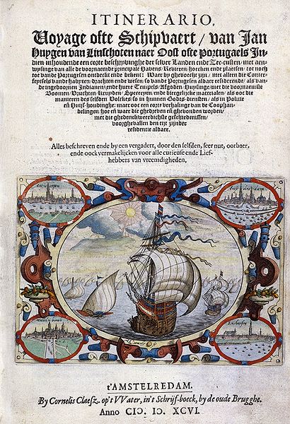
In 1596, the text of the Reys-gheschrift was included as
Book 3 in the much fuller Itinerario. This, translated and
reprinted with or without the maps, had great importance in the
discovery of the seas of Asia.
 The book, which played a key role in
shaping modes of Dutch colonial expansion, was a huge success.
Following the first Dutch edition (1596) were a German and an
English edition in 1598, a Latin edition (1599) and a number of
French editions (1610, 1619, 1638). Some of these editions
include the plates, but do not always include the maps which had
added to the success of the first Dutch edition.
The book, which played a key role in
shaping modes of Dutch colonial expansion, was a huge success.
Following the first Dutch edition (1596) were a German and an
English edition in 1598, a Latin edition (1599) and a number of
French editions (1610, 1619, 1638). Some of these editions
include the plates, but do not always include the maps which had
added to the success of the first Dutch edition.
Linschoten, Jan Huygen van: Itinerario
: Voyage ofte Schipvaert, van Ian Hughen van Linschoten naer
Oost ofte Portugaels Indien, inhoudende een corte
beschryvinge der selver Landen ende Zeecusten… / Beschryvinghe van
de gansche Custe van Guinea, Manicongo, Angola, Monomotapa, ende
tegen over de Cabo de S. Augustiin in Brasilien, de eyghenschappen
des gheheelen Oceanische Zees; midtsgaders harer Eylanden, als
daer zijn S. Thome S. Helena, ‘t Eyland Ascencion… Reys gheschrift
vande Navigatien der Portugaloysers in Orienten… uyt die
Portugaloyseche ende Spaensche in onse ghemeene Nederlandtsche
tale ghetranslateert ende overgheset, door Ian Huyghen van
Linschoten. (Amstelredam : Cornelis Claesz, 1596)
French: Histoire
de la navigation de Iean Hugues de Linscot Hollandois et de
son voyage es Indes Orientales: contenante diverses
descriptions des Pays … descouverts par les Portugais … avec
annotations de B. Paludanus … a quoy sont adjoustees quelques
autres descriptions tant du pays de Guinee … que des navigations
des Hollandois vers le Nord au Vaygat & en la nouvelle
Zembla. Le tout … nouvellement traduict en François.
([Amsteredam ; [Frankfort on Main : Laurent] : DeBry], 1610) (or
see a
copy from the University of Halle)
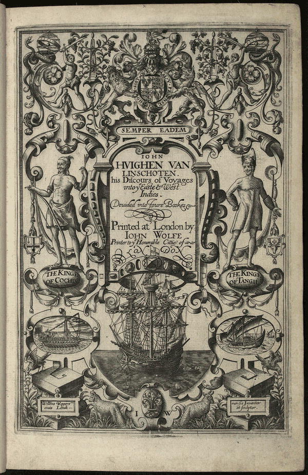
English: Iohn
Huighen Van Linschoten, His Discours of Voyages Into Ye Easte
& West Indies, Deuided Into Foure Bookes [English translation from the Dutch by William
Phillip. This book was published with the encouragement of Richard
Hakluyt] Printed at London : By Iohn
Wolfe ..., [1598] (Images of a better quality are available
from the Library of
Congress)
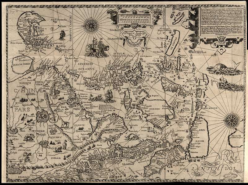
Mentions of Corea in the English edition:
(1.) Book 1, Chapter 26: Of the Iland of Iapan
Page 48 A little beyond Iapon under 34 and 35 degrees, not
farre from the coast of China, lyeth another great Island called
insula de Core, whereof as yet there is no certaine knowledge,
neither of the greatnesse of the countrie, people, nor wares that
are there to be found.
(2.) The Third Book [begins page 307] The Navigation of the
Portingales into the East Indies, containing their travels by Sea,
into East India, and from the East India into Portingall, also
from the Portingall Indies to Malасса, China, Iapon, the Ilands of
Iava and Sunda, both to and fro, and from China to the Spanish
Indies, and from thence backe againe to China, as also of all the
coast of Brasilia and the Havens thereof.
[Chapter 30 begins on page 361] The 30. Chapter. The course
together with the description of the Iland of Canton, with all the
coasts, havens, and pointes of the kingdom of China, to Liampo
& Nanquín, with the situation and stretchings of the same.
[Quotation begins in the 2nd column of page 373]
At the end of these Islands there lyeth two islands together,
whereof the Channell that runneth betweene them hath a verye good
harbour, it is called Lepion, they lie close by a great River,
which is much inhabited and frequented by Marchaunts and other
people. In this Haven of Lepion the Iapons doe often Trafficke:
from the end of this Island along by the sea coaft the land is low
and bankey ground, for that a mile from the land it is but a
fadome and a halfe deepe, being hard stones. The people of ye
country passe over it with nailed barkes, with pitched orloopes,
two peeces, sailes of reeds оr mats, in an iron dreg with sharpe
teeth. This coast reacheth Northeast to foure and thirtie degrees,
where there lieth a great river that commeth from Nanquyn, within
the mouth ог entry hath an Islапd that is inhabited by many
people, both horse and footemen. This Island maketh the
river to haue two mouthes or entries, from thence forward the land
reacheth North North East, and by East, and comming to that part
which lieth Southeast, there the land hath an end or point, and by
that meanes it maketh a great creek. From this point forward, the
coaft runneth North again, after turning again Northwestward :
Into the which coast those of Iapon do ordinarily come to
Trafficke with the Countrey people called Cooray, and there you
have Havens and harbors, having a kind of small open paeces of
woven worke, which the Iapons fetch from thence, whereof I am
certainely informed, as also touching the navigation unto that
land by pilots that have sailed and searched сleane through it, as
followeth. From this point of the Creeke of Nanquyn twenty miles
Southeastward there lyeth certaine Islands, at the end whereof on
the east side, there lyeth a very great and big Island much
inhabited, as well by horse as footemen. These Islапds by the
Portingales are called, As Ilhas de core, but the great Island
Core is called Chausien, on the Northwest sidе it hath a small
Creeke, wherein there lyeth аn Island, which is the Haven but it
is not very deep. There the Lord of the country hath his pallace
and is continually resident. Five and twenty miles Southeast from
this Island lieth the Island of Goto, one of tbe Islands of Iapon,
which lyeth from the point of the Creeke of Nanquyn East and by
North, to seaward sixtie miles, or somewhat more. This instruction
I had from a Nobleman of Portingale, called Pero da cunha, that
hath seene and travelled through all the Countrey, having by him
all advise serving for the purpose, as being of great experience,
having arrived and stayed in the Countrey aforesaid by tempest and
stогmy weather against their wils, minding to sayle to Iapon, and
from thence againe to the aforesaide Islаnd of Goto, the Islаnds
lying from this island towards thc land betweene them, and close
about them all over, are many riffes and stones. The instruction
of the creeke of Nanquyn I had from an expert Pilote borne in the
lande of Algaive in Spaigne, that lost his Shippe upon the Sands
that sticke out from the River of Nanquyn, having runne round
about all this Creeke with a Barke, and hee saide that being being
within when the sunnne rose, it came from over the land, and that
from the river of Nanquyn there ranne some sands and droughts,
reaching southward to two and thirty degrees, and to the middlе
way of the Goulfe of Iapon. Here endeth the description of the
furthest part that the Portingales have sailed, along by the
Coasts, lands, аnd Islапds of the kingdome of China, being that
part thereof which at this day is knowne and discovered.
(3.) The map by Hendrick Florent van Langren