Jean-Baptiste Régis, the describing and
mapping of Korea
 Born at Istres, Provence, 11 June,
1663, or 29 Jan., 1664; Jean-Baptiste Régis died at Peking,
24 Nov., 1738. He was received into the Society of Jesus, 14 Sept.
1683, or 13 Sept. 1679, and in 1698 went on the Chinese mission,
where he served science and religion for forty years, and took the
chief share in the making of the general map of the Chinese
Empire. For a complete account of his remarkable life, see the
online Catholic
Encyclopedia.
Born at Istres, Provence, 11 June,
1663, or 29 Jan., 1664; Jean-Baptiste Régis died at Peking,
24 Nov., 1738. He was received into the Society of Jesus, 14 Sept.
1683, or 13 Sept. 1679, and in 1698 went on the Chinese mission,
where he served science and religion for forty years, and took the
chief share in the making of the general map of the Chinese
Empire. For a complete account of his remarkable life, see the
online Catholic
Encyclopedia.
Other remarkable figures from this same period include Fr Verbiest
born 9 Oct., 1623; d. at Peking, 28 January, 1688. Jean-François
Gerbillon born at Verdun, 4 June, 1654; died at Peking,
China, 27 March, 1707
Father Régis's notes on the History of China
etc remain unpublished in a
manuscript in the French National Library : Nouvelle
géographie de la Chine et de la Tartarie
orientale
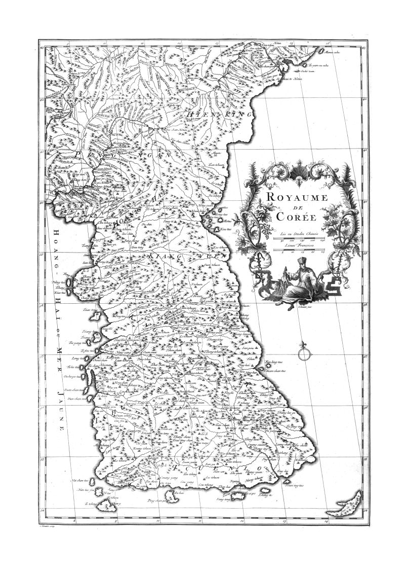
The map of Korea (left) made on the basis of
Régis' work is a landmark in the mapping of Korea and the
first map to provide a reasonable accurate mapping of the
Peninsula. In the early 18th Century, the Jesuit Missionaries were
finally able to gain access to the indigenous cartography of Korea
in an indirect fashion. Since the Jesuits were not actually
allowed into Korea the Tartar Lord (Mukedeng, a troubleshooter and
trusted assistant for the Kangxi emperor) was accompanied a
Chinese Surveyor trained by the Jesuits. While closely monitored,
they were allowed to produce a map which was exported to the
Jesuits through the Tartar Lord.
The map was produced by Jean-Baptiste Regis, transmitted to Fr.
Jean-Baptiste du Halde, was edited by d'Anville and published in
1737 in the French : Nouvel
atlas de la Chine, de la Tartarie chinoise et du Thibet.
Jean-Baptiste
Bourguignon Anville; La Haye: Henri Scheurleer. 1737.
Jean-Baptiste Du Halde (1674–1743) was a French Jesuit in Paris
who collected and edited all the materials that the French Jesuits
in China sent him. The map remained the most important and
influential mapping of Korea for the next century or more. He had
previously produced his great account of China : Jean-Baptiste Du Halde S.J., (1674-1743), Description
géographique, historique, chronologique, politique, et
physique de l'empire de la Chine et de la Tartarie chinoise,
enrichie des cartes générales et particulieres de
ces pays, de la carte générale et des cartes
particulieres du Thibet, & de la Corée; &
ornée d'un grand nombre de figures & de vignettes
gravées en tailledouce (revised edition 1736) Volume
1 ; Volume
2 ; Volume
3 ; Volume
4 [observations on Corea cover pages 529 – 560 in
volume 4]
The English edition followed soon after: The
general history of China. Containing a
geographical, historical, chronological, political and physical
description of the empire of China, Chinese-Tartary, Corea, and
Thibet. Including an exact and particular account of their
customs, manners, ceremonies, religion, arts and sciences ..
Done from the French of P. Du Halde. Volume 4, second edition
corrected. London: John Watts. 1739. The
account of Korea is in the later part of this volume.
Read a PDF file of the account of
Korea based on the records of Father Régis.